Servicios de Topografía y Geomática

Expertos en levantamientos y estudios precisos en Granada y Málaga.

Calificación: 5 estrellas

★★★★★

Sobre Nosotros

Expertos en topografía y servicios geomáticos en Granada y Málaga.

A metal topographical indicator displaying various landmarks, distances, and heights is prominently in focus. The background reveals an out-of-focus rocky terrain and a blurred figure of a person, suggesting an outdoor, elevated setting.
A topographic map is laid out on a moss-covered log next to a pine cone and a blue and green bottle cap. Sunlight illuminates the scene, creating a natural, outdoorsy atmosphere.

Servicios Geomáticos

Ofrecemos soluciones en topografía con tecnología de última generación y atención personalizada.

Levantamientos Topográficos
Hands are holding a topographic map and a compass. One hand is pointing at a specific location on the map, indicating navigation or orientation. The map is detailed with green shades, representing terrain or elevation.

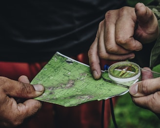
Realizamos levantamientos precisos para construcción, ingeniería civil y proyectos medioambientales.

A tripod-mounted surveying instrument is prominently placed in the foreground, with a large construction site visible in the background. Tall cranes and unfinished buildings indicate ongoing construction work, set against a clear blue sky.
An aerial view of a mountainous landscape, displaying a natural array of jagged peaks and valleys. The terrain is rugged with a combination of steep slopes and ridges interspersed with flatter areas, possibly representing terraces or fields. Shadows and light create a high contrast effect, highlighting the topographical texture.
Georreferenciación

Expertos en georreferenciación para garantizar la ubicación exacta de su proyecto.

Deslindes y replanteos de obra.

Disposición de su parcela

Suscríbete a nuestros servicios

Recibe novedades sobre topografía y geomática

Excelente servicio de topografía, muy profesionales y rápidos. La atención personalizada fue clave para nuestro proyecto. ¡Recomendados al 100%!

Juan Pérez

A surveying instrument mounted on a tall pole stands in the foreground, with a bright blue sky and scattered clouds above. In the background, there are several modern high-rise buildings, indicating an urban area.

★★★★★